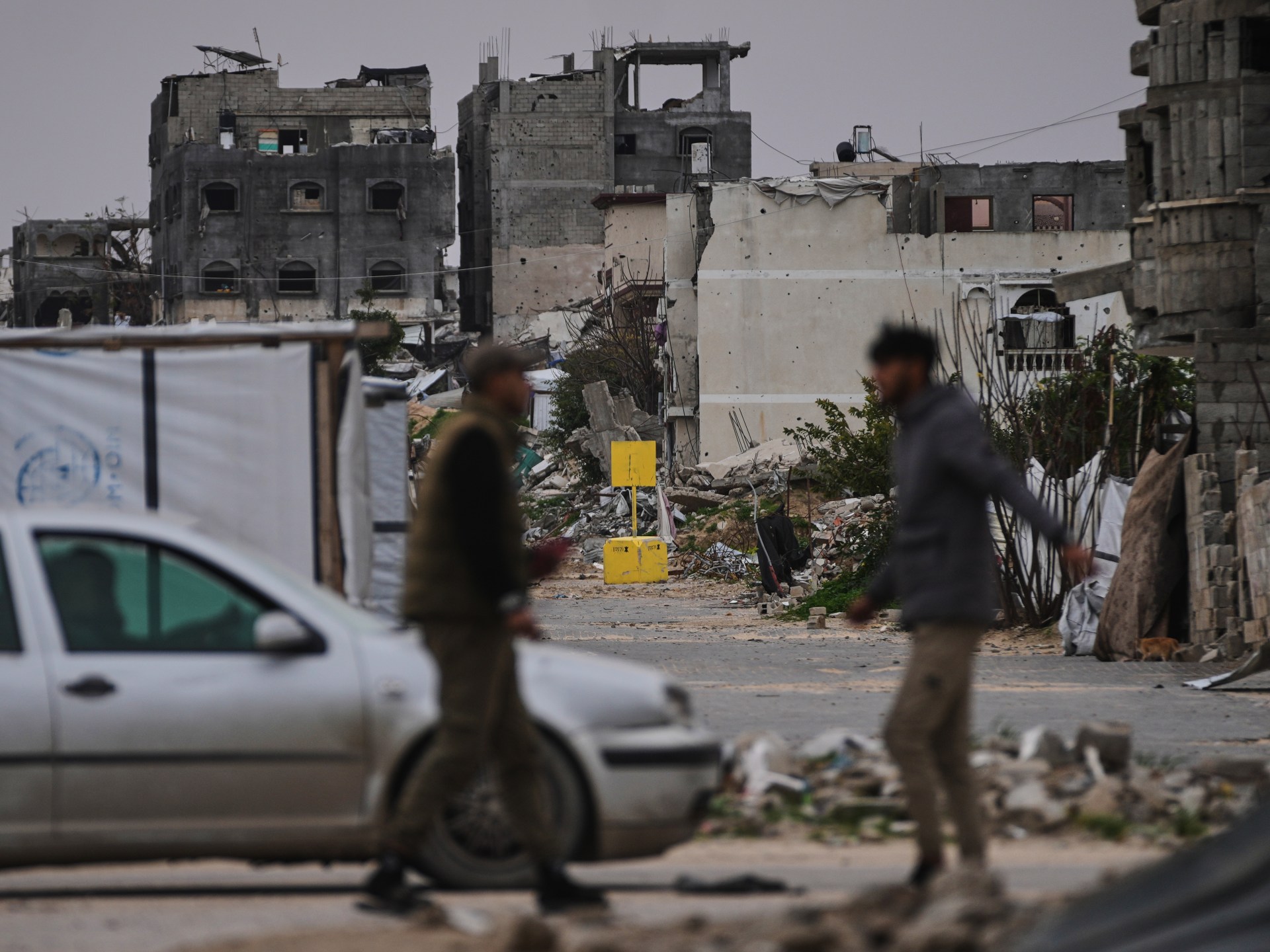

Gaza – Just metres from yellow-painted concrete blocks marking the Israeli army’s latest redeployment line in eastern Gaza City, Zaid Mohammed, a displaced Palestinian father of four, shelters with his family in a small tent.
The so-called yellow line is the demarcation line where the Israeli army withdrew to under the first phase of the Gaza ceasefire that came into effect in October. Israeli military maps indicate the line extends 1.5km and 6.5km (0.9 to 4 miles) inside Gaza from its eastern boundary with Israel and covers roughly 58 percent of the enclave.
- list 1 of 4Feet dragging, division and obstruction: What Israel really wants for Gaza
- list 2 of 4Gaza war docudrama The Voice of Hind Rajab nominated for Academy Award
- list 3 of 4‘Imperial’ agenda: What’s Trump’s Gaza development plan, unveiled in Davos?
- list 4 of 4Gaza’s tent life between illness and daily despair
end of list
The line divides Gaza into two zones: an eastern area under Israeli military control and a western area where Palestinians face fewer movement restrictions but are under constant threat of air strikes and forced displacement.
Zaid’s tent stands in the ruins of destroyed homes and a flattened urban area with debris scattered as far as the eye can see. A United Nations official last week said it would take more than seven years to clear more than 60 million tonnes of rubble in Gaza.
Israel’s more than two years of genocidal war has destroyed or damaged more than 80 percent of the buildings in the enclave of more than 2.3 million people. Now most of them, including Zaid, have been forced to take shelter in tents or bombed-out houses.
“Shelling and gunfire continue around the clock,” Zaid told Al Jazeera, pointing towards the eastern horizon, where clouds of dust occasionally rise from nearby explosions.
As Zaid spoke, the sound of drones could be heard overhead as tanks were positioned near the yellow-painted barriers.
Advertisement
“Israeli soldiers are only a few hundred metres [a few hundred yards] from here,” he explained. “At times, we hear bulldozers demolishing homes or levelling farmland. It’s dangerous to move even a few steps beyond this area.”
Residents living close to the yellow line said they frequently wake up to the sound of gunfire or small explosions.
“At night, there’s complete darkness because there’s no electricity,” Zaid added. “But soldiers use flares that briefly light up the sky.”

The yellow line refers to Israeli-designated military zones and buffer areas inside the Gaza Strip.
According to UN agencies and humanitarian organisations operating in Gaza, these zones have expanded, shifted and retracted repeatedly during the war, creating de facto boundaries that shape civilian movement, access and survival. The line functions as a powerful internal border.
During a visit to the Gaza Strip in December, the Israeli military’s chief of staff, Lieutenant General Eyal Zamir, said unequivocally that the yellow line is “a new border line”.
It leaves Israel in full control of nearly 60 percent of the devastated enclave, including the cities of Rafah in the south and Beit Hanoon in the north.
The yellow line evolved through numerous Israeli forced displacement orders over the course of the war. Those forced displacements were often issued through leaflets, phone messages or online maps while aerial bombardments were being conducted, leaving Palestinians little time to leave safely.
The UN Office for the Coordination of Humanitarian Affairs has documented that, at various points, more than 70 percent of Gaza’s territory was under forced evacuation orders or considered unsafe.
The yellow line is what many here call the shifting military zones inside Gaza. They move, expand and disappear on maps, but for civilians, they’re always there. This line decides which streets feel safe, which homes are abandoned and when it’s time to run. It may not be official, but it shapes daily life.
In many areas across the Strip, there are no clear markers or visible signage denoting the yellow line. Palestinians must rely on instinct, sound and memory.

A neighbourhood that felt safe yesterday can become dangerous overnight. Families pack quickly, often leaving homes that are still standing but no longer liveable. Most people here have been displaced at least once – many of them multiple times.
Advertisement
Living this way takes a toll. Parents watch their children learn new rules: which roads to avoid, where to hide, how to react when the sky gets loud. Aid workers said the constant uncertainty fuels anxiety, exhaustion and deep trauma, especially for children.
Mental health professionals working with the World Health Organization and UNICEF have consistently reported high levels of anxiety, insomnia and trauma linked to uncertainty and being under constant threat.
Children, in particular, have adapted to new “maps” of safety – learning which streets are forbidden and which directions to run in during shelling.
Aid organisations noted that this normalisation of danger has long-term psychological consequences, especially for those living near military zones.
The yellow line also cuts into livelihoods.
Farmers can see their land but can’t reach it. Jobs disappear when workplaces fall too close to unsafe areas. Even when the bombing slows, fear keeps people from returning.
The Food and Agriculture Organization has documented extensive loss of farmland due to restricted access, shelling and military activity near boundary areas.
Even in moments of calm, the yellow line doesn’t go away. It continues to shape where people live, how they move and whether they dare to rebuild.
It isn’t drawn on the ground – but it’s written into daily life.
![]()
Related News
Russia-Ukraine war: List of key events, day 1,424

Astronauts depart International Space Station after medical emergency

EU, Mercosur bloc sign free trade deal after 25 years of negotiations